
 "It all begins with the Map!"
Integrated Mapping
Providing the tools to manage the map that works with your applications.
GeoAuthor® and GeoAuthorGT™ have been designed to manage similar but distinctly different geospatial databases. GeoPoints is included with both products.
TIGER/Line Shapefiles are distributed as topologically stored data which GeoAuthor® is expressly designed to edit from full conflation of TIGER geometry to tabular attributes and the addition of missing features. Many organizations may prefer to work with their own data maintaining topology similar to TIGER. This is where GeoAuthorGT™ was designed to be used. The following illustrates the Vertical Integration of Multiple Layers of Geographic Features provided by the US Census Bureau and footnoted below the illustration. The Bureau refers to the lines in the bottom layer as edges and the enclosed polygons as faces. Census blocks are constructed from the faces. There may be a one-to-one relationship between some of the faces and resulting blocks or some blocks may contain more than one face. In the case of GeoAuthorGT™ faces and bocks have a one-to-one relationship in the entirety of the area of the map. Both GeoAuthor® and GeoAuthorGT™ have the ability to split blocks in order to conform to various geopolitical boundaries. Full topology is maintained during a block split and subsequent iterations of the block tables can be replicated from the linear networks because of the preservation of topology.
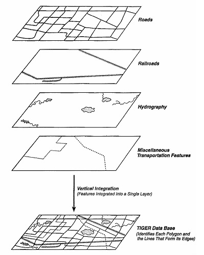
The illustration above is made available curtesy of: 1990 CPH_R_2C, US Department of Commerce, U.S. Government Printing Office, Washington, DC 20402, Issued 1995. Page 3-23.
In the case of GeoAuthorGT™, the user may select multiple non-topologically stored layers/shapefiles with which to define their own GIS database stored with topology. Following is a non-exhaustive list of benefits associated with Geospatial Topology:
GeoAuthor® and GeoAuthorGT™ operate in ArcMap. Both ArcMap Advanced and Standard are supported. Click here for A Quick Tour of ArcMap.
While the discussion below refers to GeoAuthor®, both GeoPoints© and GeoElections® work with GeoAuthorGT™.
GeoAuthor® provides both a methodology and tools with which to create a project for a county with US Census TIGER/Line Shapefiles. GeoAuthor® streamlines user edits to both geometry and tabular attributes. Including automated conflation tools for realigning TIGER to local geometry (e.g. center street maps, parcel maps, aerial photos, etc.), adding missing features (e.g. streets, water, landmarks, etc.), modifying tabular attributes (e.g. names, address ranges, ZIP Codes, etc.) and confirm data integrity with diagnostic routines.
GeoPoints©is used to create and maintain geographic databases of points and associated tabular attributes. Automated conflation tools are also provided with GeoPoints© for fast and efficient creation of discrete location data.
GeoElections®is used with GeoAuthor® and GeoPoints©. They provide the user with an intuitive set of tools for managing a digital map of the jurisdiction covered by the responsible elections authority. A major benefit to the elections office with this architecture is the ability to create a street file for the VR as an extract of the digital map. Another major benefit is in the use of the US Census Bureau TIGER/Line Shapefiles as the basis for the map data. These files provide a ready base map for geocoding voters and generating maps of blocks that can be combined to create precincts.
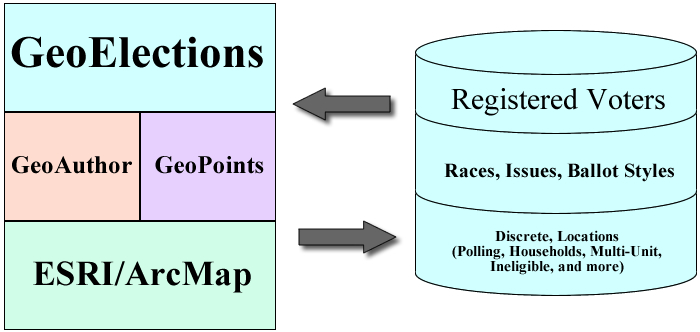
Interoperability is fundamental to the architectural design of GeoElections® which supports multiple Voter Registration Systems around the country. Combine the operational efficiencies and data integrity of GeoElections® with the focused power of ArcMap and the people who manage the elections process, will benefit from all aspects of best practices in the class. GeoElections® harness and focuses the power of ArcMap specifically for the people who manage the elections process.
Conflation Layer
Conflation Layer provides an interface with which to conform the tabular data in a street center line map for use as a backdrop to the format necessary for use with the Add Segment and Trace functions within GeoAuthor®.
For use with GIS, E911 or NG911 mapping work products, the Conflation Layer function in GeoPoints works similarly. In both cases, this opens up the ease of data sharing with the primary authors of linear and point data for any county.
Geocoding
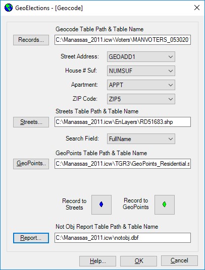
With the GeoElections® geocoder the location of the voter can be determined using a table of roads with ranged addresses, discrete points or both.
Extensions and Custom Toolbar
As extensions, ICW software integrates to focus the diverse functionality of ArcMap to the specific needs of the elections office. Even a custom toolbar is included.
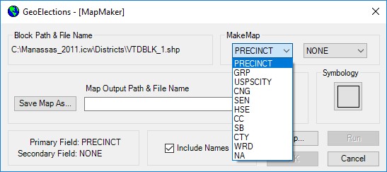
MapMaker
MapMaker creates map layers of various areas of geographic items using the block table defined in GeoElections®. Each block in the block table has been assigned a precinct, group, uspscity, etc. From the block table MapMaker will construct a new table of discrete polygons for any of the district attributes defined in the block table.
Call for additional details about GeoAuthorGT™ and GeoPoints©.