 "It all begins with the Map!"
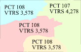 Tools to construct the perfect geographic model of streets, points and boundaries to geocode voters and tabulate at the precinct or block level. When your legislature completes redistricting you can easily reprecinct and automatically update your voter registration system from the map with GeoElections®. Click Here to find out More >>
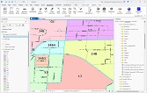 Meet the new GeoElections for ArcGIS Pro—faster, more powerful, and built for modern election mapping. Discover how the upgrade streamlines precinct management and reporting with a smarter, more intuitive experience.
Click Here to find out More >>
 Don't Forget to read up on the GeoElections® Newsletter.
Managing geographically
Cost savings resulting from greater efficiency
Better decision making