
 "It all begins with the Map!"
GeoElections News
 Temple Terrace, FL www.icwmaps.com VOL. 17 NO.1 -
  $.50
$.50 
The 18th Annual GeoElections User’s Conference – December 2019
Another outstanding GeoElections Conference was conducted for veterans and new users alike. With guest speakers Thomas Morton, Assistant Chief of the Census Redistricting and Voting Rights Data Office along with Jennie Karalewich, Lead Redistricting Program Specialist and presentations by the people at ICW. The Conference was a great opportunity for both professional networking and information rich content.

The focus this year was upon the Voting District Project, VTDV2 and the release of GeoAuthorVTD 2019 to work with the Partnership Shapefiles VTDV2 Phase. These files are available to download from https://www.census.gov/geographies/mapping-files/time-series/geo/partnership.html. These files can be used with GeoAuthor VTD 2019 which can be down loaded from http://www.icwmaps.com/downloads.php. The activation code for installing GeoAuthorVTD 2019 is 192VTD18353 followed by the ICW client identification code. GeoElections Users from two states and speakers alike made the 18th a great conference!
Tom Morton, described the 2020 Census Operations underway, how households can respond to the Census and tabulation activities to create the P.L. 94-171 used for redistricting across the US. 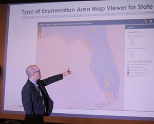
| Jennie Karalewich, presented her audience with the Census VTD2 Jeopardy Game. “With a lifelong admiration of Alex Trebek, I wanted to have my own Jeopardy Game,” Jennie explained. 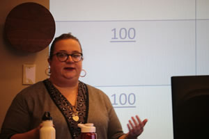 Jennie divided the audience into three teams and proceeded to ask questions in Jeopardy fashion both educating and entertaining her audience with glee. |

St Johns County, FL SOE Deploys GeoElections for ArcMap
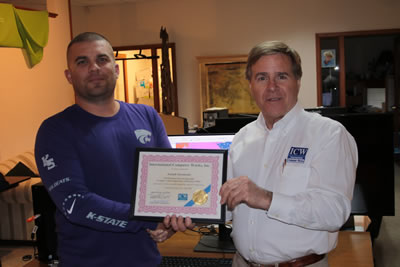
Joseph Sarmiento, GIS Elections Services Specialist for St Johns County Supervisor of Elections receives a Certificate of Completion for his training in the use of GeoAuthor, GeoPoints and GeoElections for use with ArcMap, December 12th, 2019. St. Johns County Office of the Supervisor of Elections is the first client to adopt GeoElections and the associated modules for running in the ESRI ArcMap environment. During the training, Joe learned and completed a number of tasks and processes which represented real work updating and enriching his GeoElections project and the street index in his voter registration system. Following are examples of the work Joe was able to complete. This is not an exhaustive list but does serve to illustrate the power of GeoElections and ArcMap.
Using the GeoAuthor Conflation Layer, Joe converted a 911 center street file for use with the conflation tools in GeoAuthor. Joe was able to use the file to identify new, realigned or renamed roads and then use the file to update his map. In this example he was able to easily and accurately update his GeoElections data layer. Step One required a Node Combine to remove a line and maintain topology. The resulting red line was then set aside from the network. In step Two, a line in the backdrop, Stadium Course Way was selected to Trace, updating the addresses for the Geo segment.
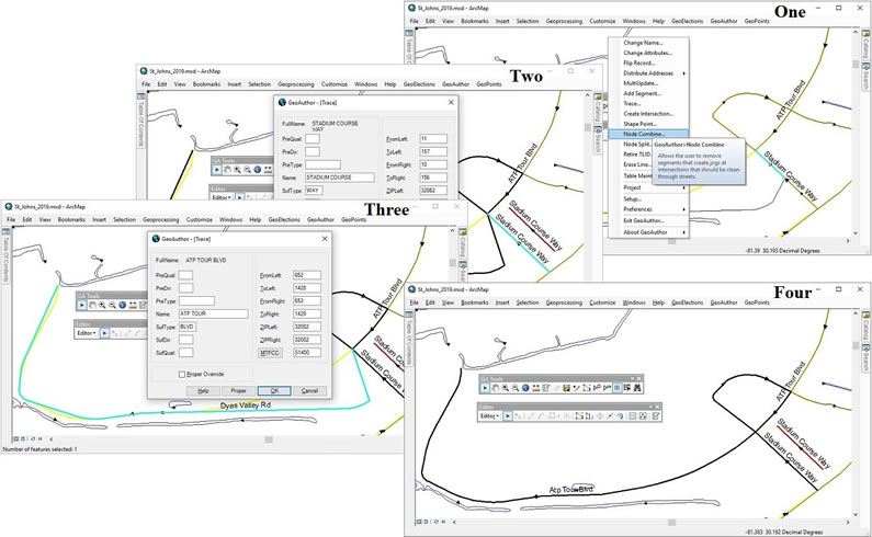
Joe snapped the northwest end of his segment for Dyes Valley Rd to the corresponding 911 line. The 911 people had changed the name to Apt Tour Blvd . In step Three, Joe used the Trace function in GeoAuthor a second time to capture both the geometry and tabular attributes from the backdrop. With each use of the Trace function, GeoAuthor presented a dialog box for Joe’s review, displaying the tabular attributes from the backdrop before accepting the data. Four displays the results. Joe then created a Dictionary using GeoElections to import into his voter registration system to update the street index. This project used the US Census P.L. 94-171 data conflated to a local center street line and full topology was preserved in all edits. This allows the project to use Census blocks for all geopolitical definitions.