 "It all begins with the Map!"
GeoElections News
 Temple Terrace, FL www.icwmaps.com VOL. 16 NO.2 -
  $.50
$.50 
|
Texas 37th Annual Election Law Seminar for County Election Officials
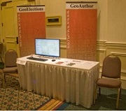
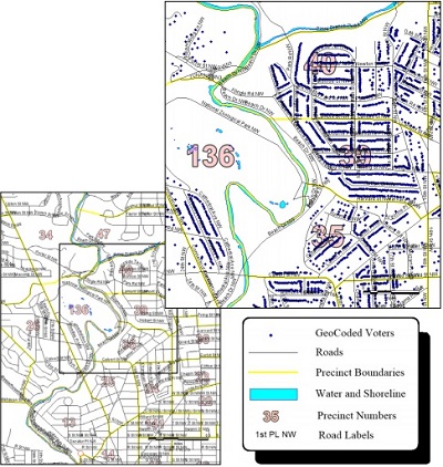
Look for ICW and stop by to view our latest GeoElections product set. ICW will be in attendance at the 37th Annual Conference hosted by the Texas Secretary of State. The event is held in Austin, TX, the capitol for Texas. Working with the staff at Votec, Corporation, ICW has built an interface to Votec’s voter registration system, VEMACS™. This interface provides the user the means to update the VEMACS™ street files with an extract from the GeoElections database. ICW staff will provide demonstrations of GeoAuthor, GeoPoints, and GeoElections using a model built for Hays County, TX or Washington DC. GeoElections runs in ArcGIS thus fitting into the broadly deployed GIS of choice by county governmental units across the state of Texas. We look forward to talking with you at the conference. Big or small, we serve them all. Washington DC Board of Elections Checks Out GeoElections The nation’s capital is approximately 10 square miles and is home to over 622,000 voters. The tallest structure is the Washington monument with the exception of some radio towers. Given the significant federal government presence in, there is an extreme density of housing. Earlier this year the DC Board of Elections selected a new voter registration system, Voter Focus from VR Systems out of Tallahassee, FL. The Board also initiated a search for a GIS solution to use with Voter Focus. The ICW response resulted in a database of DC data designed for use with GeoElections. ICW geocoded DC voters using a set of points representing structures. These points
structures. These points were provided by the Office of the Chief Technology Officer for the District (OCTO). Within OCTO there is a GIS group referred to as DCGIS. They provide GIS services for numerous District agencies. One of those agencies is the DCBOE. The staff at ICW used OCTO’s center street lines and assorted geopolitical boundaries to which they conflated the TIGER/Line Shapefiles. DC is one of the numerous entities in the US that uses TIGER geography as the basis for creating precincts along with other geopolitical boundaries. The DCBOE understands the benefits quality GIS data can provide in the process of creating an accurate VR street index used to determine ballot assignment at the polling place, early voting and vote by mail. |
GeoElections - Designed To Empower Elections Offices with ArcMap
|
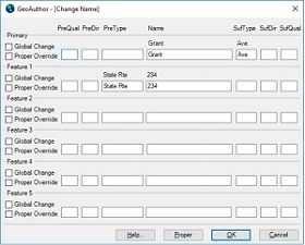
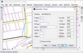
The powerful features in GeoElections synthesize the strength of ArcMap providing a set of tools and data management techniques that subscribe to the most demanding definition of “Best Practices”. ICW’s goal has been to create software to simplify the use of GIS in order for a member of the elections staff to manage, create, update and maintain map data specific to the needs of the office. ICW makes GIS available to non-GIS staff while increasing the productivity of the most talented GIS Analysts. For example, managing street names is simplified with the GeoAuthor Change Name function. Select a street segment and activate the
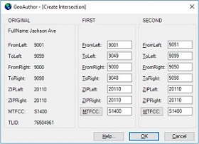
Change Name dialog box which offers context sensitive Help. One can easily edit the naming for one or many street segments, a primary and up to 5 alternate street names using the Global and Proper Override functions. MultiUpdate provides a workflow to manage some segments, one to thousands. Select the segments to edit and fill in the dialog box updating ZIP Codes, MTFCC values or revert graphics. As segments are edited, GeoAuthor bolds the segments, providing a visual confirmation of the edited segments. Revert graphics rolls back symbology to a pre-edit state. The Create Intersection dialog box is accessed after the user has selected a segment to split, thus creating an intersection along either a line or polyline. A line has been selected and GeoAuthor has distributed the addresses 50-50. If this had been a polyline split 40-60, the addresses would be distributed proportionate to the
resulting line lengths. In both cases the author can edit the distribution of these addresses.
The Trace function requires the user to snap the ends of a segment in the table being edited to a backdrop from which to conflate both geometry and tabular attributes. Then select the segment to be edited and activate the Trace function.
The ability to conflate maps A and B creating map C is a powerful technology. The ease with which GeoAuthor facilitates this powerful technology once again brings GIS into the hands of the non-technical user and makes the most accomplished user more productive. While GeoAuthor manages linear networks, GeoPoints provides end-users with the tools to create, edit, conflate and maintain databases of discrete points. GeoPoints can be polling places, commercial sites and residential locations from single family to multi-residential. GeoElections works with both point and ranged addressing as independent databases or a hybrid database. Once the GeoElections database has been perfected, the user can update the voter registration database with data of the highest integrity. |