 "It all begins with the Map!"
GeoElections News
 Temple Terrace, FL www.icwmaps.com VOL. 15 NO.2 -
  $.50
$.50 
|
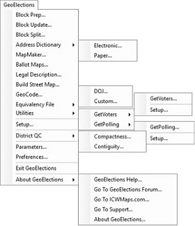
GeoAuthor®, GeoPoints© and GeoElections® Now Available for Esri’s ArcMap Platform Working with the people at Esri, the comprehensive suite of applications included with GeoElections are available for ArcMap users. GeoElections builds upon the rich functionality of ArcMap to focus its broad range of power to meet the specific needs of the Elections office. GeoElections interoperates with multiple voter registration systems providing a bridge with GIS technology. The two-way interoperability increases the integrity of the data used in voter registration systems for redistricting, precincting, annexations, address management and more ultimately resulting in accurate ballot assignments.
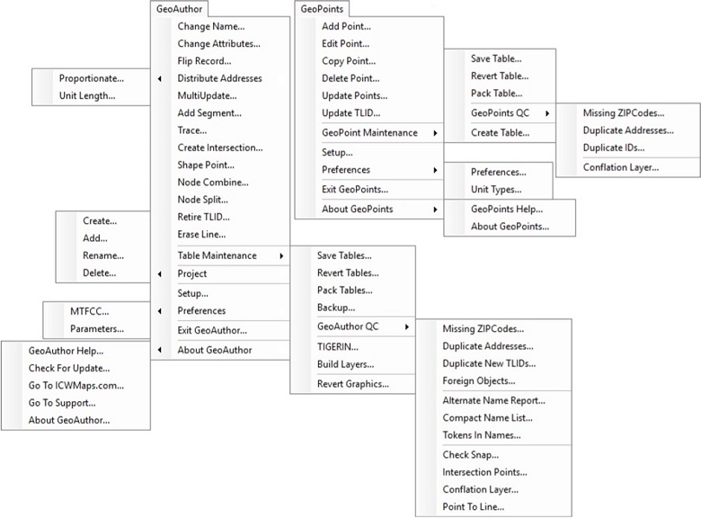
GeoAuthor provides easy-to-use tools to create a project for a county using TIGER/Line Shapefiles provided by the US Census. Once the project is created GeoAuthor permits the user to make edits to the geometry and tabular attributes of the map data. This includes realigning TIGER to local geometry (i.e. road centerlines, parcel maps, aerial photos, etc.), adding features (i.e. streets, water, landmarks, etc.), modifying tabular attributes (i.e. names, address ranges, ZIP Codes, etc.) and use the diagnostic routines in GeoAuthor to confirm the integrity of the data. GeoPoints is designed to create and maintain points and tabular attributes. Conflation tools leverage externally created GIS data for easy updates. |
| GeoElections is built upon the experience to deliver tools and methodology that define “best practices” in the endeavor of GIS applied to Elections management. GeoElections has been shown by research and experience to produce optimal results setting standards which are now available for use with ArcMap. • Specifically designed for elections with up to date features that make GeoElections uniquely positioned to assist you and your staff to better meet your management goals and objectives.
• Editing TIGER/Line or Shape Files allows you to use the same data your state legislature will use for redistricting, the P.L. 94-171 data. |
| We empower the people who manage the elections process.
GeoAuthor, GeoPoints and GeoElections as extensions in ArcMap appear on the ArcMap menu bar as pull down menus. The exploded views of these menus appear on pages 1 and 2. This flexibility allows the integration of GeoElections to operate as a set of seamless applications harnessing the power of ArcMap for use with an intuitive and user friendly interface. Esri and ICW remain committed to bring the best of GIS to the practice of elections management. With this newly released deployment, a new standard has been set for the ability of Elections offices to leverage GIS technology to provide more accurate data and extended services to the voting population. |