 "It all begins with the Map!"
GeoElections News
 Temple Terrace, FL www.icwmaps.com VOL. 12 NO.1 -
  $.50
$.50 
|
The 13th Annual GeoElections User’s Conference – December 2014 With over 45 professionals in attendance, the 2014 GeoElections User’s Conference was the largest in attendance since our first event in 2001, conducted at the ICW offices with meals served in a large tent under pleasant skies. The topics discussed this year included the introduction of new features in GeoAuthor 3.0, the release of a 64 bit version of MapInfo including a new interface with ribbons replacing pull down menus and continued improvements in the use and interoperability of GeoElections and Voter Focus. An enthusiastic group of attendees fired off questions and shared suggestions on methods for expanding the uses of their GeoElections databases to increase benefits for the voting public. Tamara Holmes, Customer Support Team Member and Trainer with VR Systems, Inc. and Tom Probert, Product Manager for MapInfo Professional with Pitney Bowes (PB) were the two guest speakers on the agenda this year. The group photo was provided by Wayne Fusco.
Tamara Holmes and Ken Tozier conducted a workshop addressing issues pertaining to importing dictionaries with streets designated as commercial in conjunction with the use of discrete points. Discrete points are addresses managed in the GeoElections database as GeoPoints and can be used to represent residential or business addresses. Once imported to the voter registration database, those addresses identified as non-residential can be used to flag registrations to those addresses for further research before acceptance. Tom Probert provided a live demonstration of the 64 bit version of MapInfo and discussed numerous differences users will experience as they familiarize themselves with the new ribbon style menus. Tom spoke of the ongoing commitment PB has regards feature enhancements to MapInfo Professional, meeting the demands of both worldwide and US clients. Tom responded to numerous questions about the MI Pro products with concrete examples and explanations. Tom provided an excellent training session on the similarities and differences users of both the 32 and 64 bit versions will observe. He encouraged all clients to install both versions of MapInfo on their machines simultaneously and run either version without conflict to further their understanding about the 64 bit version as the product evolves. The concept of the ribbon is consistent with the user interface found in Microsoft Office. New features demonstrated with GeoAuthor 3.0 included context sensitive Help and context sensitive videos. Also demonstrated was conflation technology added to streamline the use of street files produced by agencies such as county 911 or GIS departments and a feature called Conflation Layer matches fields in the street file to the GeoAuthor database. The Add Segment tool can copy a segment from the backdrop directly into the database while the Trace tool adopts the geometry of the back drop and updates the attribute data with a click of the mouse. The best conference yet! |
GeoAuthor 3.0 Ready for Distribution 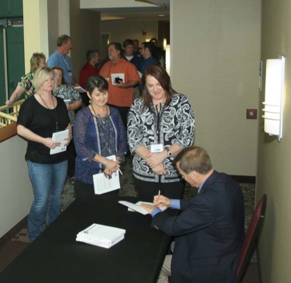
Innovation That Establishes A New Threshold In Design With the introduction of Version 3.0 of GeoAuthor, ICW has incorporated context sensitive computer based training (the CBT button), context sensitive help (the Help button), a convenience feature called Conflate with which to map the fields in an external center street file to the GeoAuthor database for use with the conflation tools included in Add Segment and Trace. During the second half of 2014, ICW rewrote much of GeoAuthor using C# to obtain portability across platforms. This opened the door for the enhancements listed above. GeoAuthor is a core component of the GeoElections product set. The GIS knowledge of GeoAuthor users ranges from the GIS professional to the casual user. The feature enhancements in Version 3.0 deliver a more refined ease-of-use that enhances the user experience in terms of understanding and shear brute power.
Using the Add Segment dialog box as an example, depressing the CBT button launches a video with Section 508 compliant embedded closed captioning for the hearing impaired. Even with full hearing, the text provides another means to reinforce the content of the narration. Depressing the Help button launches context sensitive help which contains step-by-step instructions for the use of the topic for which help has been sought, along with an abundance of detailed illustrations integrated into the instructional information. Between the CBT’s and Help database, details for success in the use of GeoAuthor have been integrated to ensure the overall quality of the user experience. Innovation so obvious one is left wondering why the people at ICW did not add these features in prior releases.
The other feature set added to Version 3.0 includes sophisticated conflation technology to leverage the productivity of the GeoAuthor users possessing diverse skill levels from intermediate to expert. The conflate functionality will neither insult the expert nor fall outside the grasp of the novice. The illustration below contains a center street line map from an To make the task easier, Version 3.0 includes a Conflate feature, giving the user an interface for matching the data fields in the backdrop to the data fields in the GeoAuthor database. Again, innovation that sets a new threshold for functionality in GIS. |